Drawing wind barbs
SVG example from the arrows and barbs section.
The data is taken from the GFS model, following these steps:
- Download at a link like this one (dates may not be available): http://www.ftp.ncep.noaa.gov/data/nccf/com/gfs/prod/gfs.2016112400/
- Running gdalinfo gfs.t00z.sfluxgrbf00.grib2, see that the bands 50 and 51 are UGRD and VGRD at 10-HTGL (surface wind)
- Run gdal_translate -b 50 -b 51 -projwin 17 50 47 29 gfs.t00z.sfluxgrbf00.grib2 /tmp/gfs.tiff
- Note that the geotiff-js library has some problems with compression
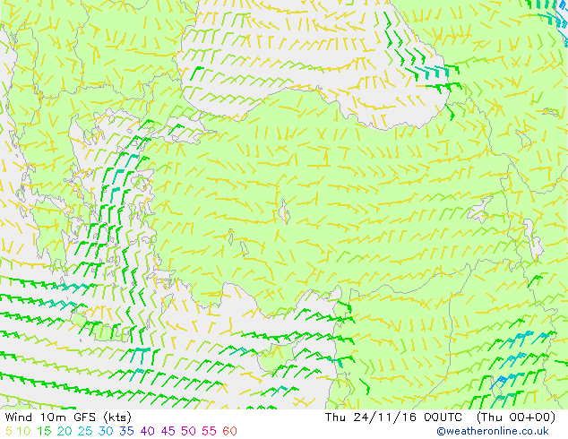
- This image, taken from weatheronline, shows that the barbs are coherent with other source images
<!DOCTYPE html>
<meta charset="utf-8">
<body>

<script src="https://d3js.org/d3.v4.min.js"></script>
<script src="geotiff.min.js"></script>
<script src="http://d3js.org/topojson.v1.min.js"></script>
<script>
var width = 680,
    height = 500,
    barbSize = 30;

var projection = d3.geoConicConformal()
    .rotate([-33, -5])
    .center([0, 34.83158])
    .scale(2000)
    .translate([width / 2, height / 2]);

var path = d3.geoPath()
    .projection(projection);

var svg = d3.select("body").append("svg")
    .attr("width", width)
    .attr("height", height);

d3.request("gfs.tiff")
  .responseType('arraybuffer')
  .get(function(error, tiffData){
d3.json("world-110m.json", function(error, topojsonData) {

  var countries = topojson.feature(topojsonData, topojsonData.objects.countries);
  svg.insert("path", ".map")
      .datum(countries)
      .attr("d", path)
      .style("fill", "#ccc")
      .style("stroke", "#777");

  var tiff = GeoTIFF.parse(tiffData.response);
  var image = tiff.getImage();
  var rasters = image.readRasters();
  var tiepoint = image.getTiePoints()[0];
  var pixelScale = image.getFileDirectory().ModelPixelScale;
  var geoTransform = [tiepoint.x, pixelScale[0], 0, tiepoint.y, 0, -1*pixelScale[1]];

  var uData = new Array(image.getHeight());
  var vData = new Array(image.getHeight());
  var spdData = new Array(image.getHeight());
  for (var j = 0; j<image.getHeight(); j++){
      uData[j] = new Array(image.getWidth());
      vData[j] = new Array(image.getWidth());
      spdData[j] = new Array(image.getWidth());
      for (var i = 0; i<image.getWidth(); i++){
          uData[j][i] = rasters[0][i + j*image.getWidth()];
          vData[j][i] = rasters[1][i + j*image.getWidth()];
          spdData[j][i] = 1.943844492 * Math.sqrt(uData[j][i]*uData[j][i] + vData[j][i]*vData[j][i]);
      }
  }

  var xPos = d3.range(barbSize, width, barbSize);
  var yPos = d3.range(barbSize, height, barbSize);

  xPos.forEach(function(x){
    yPos.forEach(function(y){
      var coords = projection.invert([x,y]);
      var px = Math.round((coords[0] - geoTransform[0]) / geoTransform[1]);
      var py = Math.round((coords[1] - geoTransform[3]) / geoTransform[5]);

      var angle = (180/Math.PI) * Math.atan2(-vData[py][px],uData[py][px]);
      var spd5 = Math.round(spdData[py][px]/5);
      var spd10 = Math.floor(spd5/2);
      spd5 = spd5%2;
      var spd50 = Math.floor(spd10/5);
      spd10 = spd10%5;

      var g = svg.append("g")
      .style("fill", "#444")
      .style("stroke", "#444")
      .attr("transform", "translate("+x+", "+y+")rotate("+angle+")");

      var pos = -barbSize/2;
      var separation = 2.5;
      for(var i=0; i<spd50; i++){
        g.append("path")
          .attr("d", "M"+pos+",0L"+(pos+barbSize/8)+","+(barbSize/4)+"L"+(pos+barbSize/4)+",0Z");
        pos = pos + barbSize/4 + separation;
      }
      for(var i=0; i<spd10; i++){
        g.append("line")
        .attr("x1", pos)
        .attr("y1", 0)
        .attr("x2", pos)
        .attr("y2", barbSize/3);
        pos = pos + separation
      }
      if(spd5==1){
        if (pos == -barbSize/2){
          pos = pos + separation
        }
        g.append("line")
        .attr("x1", pos)
        .attr("y1", 0)
        .attr("x2", pos)
        .attr("y2", barbSize/6);

      }

      if(spd5==0 && spd10== 0 && spd50==0){
        g.append("circle")
        .attr("r", 4)
        .attr("cx", 0)
        .attr("cy", 0)
        .style("fill", "None");
      } else {
        g.append("line")
        .attr("x1", -barbSize/2)
        .attr("y1", 0)
        .attr("x2", barbSize/2)
        .attr("y2", 0);
      }

    });
  });


});
});
</script>

</body>