A tracking tool with Supabase and Svelte
In the previous post I explained a fast way to use Supabase with Svelte to store and show geographical data. Supabase offers a really cool way to use websockets so the page updates when some data in the database changes. They call it subscription and it’s adding subscribe() function on a select.
So I created this new example. On a mobile phone (allowing geolocation), we write the location into the database, and on another device you can follow the position in real-time. Everything without having to install any library except for Supabase! You can get the source code and see the demo page. When using on a mobile device, always use https or the geolocation will be deactivated.
The app
The first screen asks if you want to create a track or follow one:
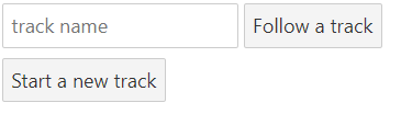
When selecting Start a new track, a random name will be assigned to it so it’s possible to use it with the option Follow track from any other device.
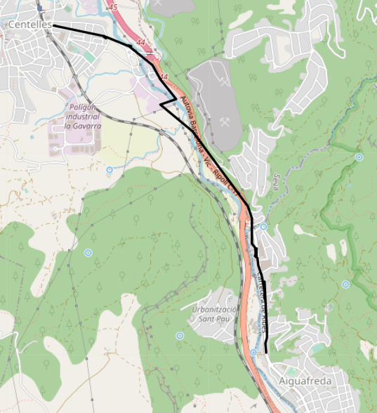
In both cases, you will see the map with the track:
Supabase
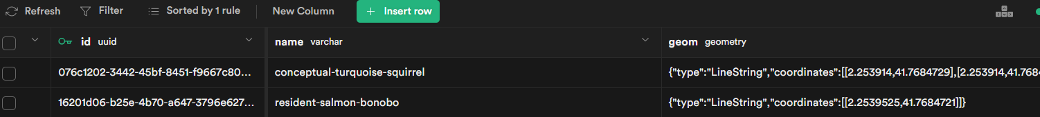
To run this project, we’ll use a single table. The table looks like this:
-
The name field will be used to follow a single track. Only who has created it knows the name, so you can follow only your tracks
-
geometry has the track, which is a linestring. Ideally, it could be a multilinestring and divide the track in sections if the GPS stops or something, but this is out of the scope for a simple demo
-
The geometry column is created running:
SELECT AddGeometryColumn (”,‘tracks’,‘geom’,4326,‘LINESTRING’,2);
So it’s that easy! Now, the function to add a new point:
create or replace function addTrackPoint (track_name varchar, lon float, lat float)
returns SETOF tracks as

$$
declare
return_record tracks%rowtype;
begin

  update tracks set geom = ST_AddPoint(geom,
      ST_SetSRID(
      ST_MakePoint(lon, lat),
      4326),
      -1
  )

       where name = track_name
  returning *
    into return_record;
  if found then
    return next return_record;
  else
    insert into  tracks(name, geom) values (track_name, ST_MakeLine(
          ARRAY[ST_SetSRID(
      ST_MakePoint(lon, lat),
      4326)
      ]))
    returning *
    into return_record;
    return next return_record;

  end if;

end;
$$

language plpgsql;
So, since we don’t have a real backend, only SQL calls, the logic has to go in the database itself, which is good to remember the SQL you forgot!
The idea is sending a longitude and latitude so the geometry updates adding the new point and returns the data with the new linestring back to the user.
- We want to get the result of the insert, so we declare the type as the table row type and use the returning clause so we can get the updated linestring directly after inserting a new point
- PostGIS has many functions to manipulate geometries. For the update, we use ST_AddPoint and ST_MakeLine for the insert
- We are actually using an upsert which means inserting when the record doesn’t exist and updating it otherwise. The if found then part is the one that checks the update result and runs the insert if nothing was updated.
- A new point can be added now from the Supabase library:
await supabase.rpc("addtrackpoint", {
  track_name: trackName,
  lon: lng,
  lat: lat,
});
Or using SQL, with:
SELECT addtrackpoint('track_name', lon, lat)Svelte Code
You can check the code on GitHub, I’ll comment on the basic points only:
- Check the last post to see how I created the basic project
- I created two stores in at stores.ts
import { writable } from 'svelte/store';

export const track = writable({
type: "LineString",
coordinates: [] as [number, number][]
});

export const mapCenter = writable([0, 0]);
Doing it like this, we don’t re-render all the map if we have to pass the linestring as a prop, since only the track component will listen to the store. The store can be updated on the root component. mapCenter is used to set the center of the map when opening or creating a track.
- The Map Component uses svelte-leaflet to create the map. This allows using leaflet as components. Check its docs to see how it’s installed (or take a look at the rollup.config.js file in the project)
<script>
import {LeafletMap, TileLayer} from 'svelte-leafletjs';
import MapTrack from './MapTrack.svelte';
import { mapCenter } from './store.js';

    let mapCenterValue;

    const unsubscribe = mapCenter.subscribe(value => {
        mapCenterValue = value;
    });

    const mapOptions = {
        center: [mapCenterValue[1], mapCenterValue[0]],
        zoom: 15,
    };

    const tileUrl = "https://{s}.tile.openstreetmap.org/{z}/{x}/{y}.png";

    const tileLayerOptions = {
        minZoom: 0,
        maxZoom: 20,
        maxNativeZoom: 19,
        attribution: "© OpenStreetMap contributors",
    };

    let leafletMap;

</script>

    <LeafletMap bind:this={leafletMap} options={mapOptions}>
        <TileLayer url={tileUrl} options={tileLayerOptions}/>
    	<MapTrack/>
    </LeafletMap>
The store is used to get the center of the map and a MapTrack component is added to show the track. This way, when the track updates, only this layer is re-rendered, which is much more efficient.
- The MapTrack component looks like this:
<script>
import {Tooltip, Polyline} from 'svelte-leafletjs';
import { track } from './store.js';

    let trackValue;

    const unsubscribe = track.subscribe(value => {
    	trackValue = value;
    });

</script>

<Polyline latLngs={trackValue.coordinates.map(d=>[d[1],d[0]])} color="#000000">
<Tooltip>Resorts World Sentosa to Vivo City</Tooltip>
</Polyline>
Using the store makes it so easy!
- The App.svelte file is the one that does most of the job:
<script lang="ts">
import { supabase } from "./supabaseClient";
import type { RealtimeSubscription } from '@supabase/supabase-js'
import { onMount } from 'svelte';
import { uniqueNamesGenerator, adjectives, colors, animals } from 'unique-names-generator';
import Map from './Map.svelte';
import { convertWkb } from './read-wkb';
import { track, mapCenter } from './store.js';
let lng = 0;
let lat = 0;
let mode:"read"|"write";
let trackName: string;
let mySubscription:RealtimeSubscription
onMount(() => {
if (navigator.geolocation) {
navigator.geolocation.watchPosition(displayLocationInfo, ()=>{console.log("ERROR");}, { enableHighAccuracy: false, timeout:60000, maximumAge: 0 });
} else {
alert("NO GEOLOCATION");
}
});

    const displayLocationInfo = async  (position: GeolocationPosition) =>{
    	lng = position.coords.longitude;
    	lat = position.coords.latitude;
    	if(mode === "write"){

    		const {data}= await supabase
    			.rpc('addtrackpoint', {track_name: trackName, lon: lng, lat:lat});
    		data.length>0 && track.set(data[0].geom);
    		console.log("New position", lng, lat, "-->", data[0].geom);
    	}

    }

    const startWrite = async () => {
    	trackName = uniqueNamesGenerator({

dictionaries: [adjectives, colors, animals],
separator: "-"
});

    	const { data } = await supabase
    		.rpc('addtrackpoint', {track_name: trackName, lon: lng, lat:lat});

    	mode = "write";
    	console.log("Writes", data);
    	mapCenter.set([lng, lat]);
    	data.length>0 && track.set(data[0].geom);
    }

    const startRead = async () => {

    	const { data, error } = await supabase
    			.from('tracks')
    			.select()
    			.filter('name', 'eq', trackName);

    	data.length>0 && track.set(data[0].geom);
    	data.length>0 && mapCenter.set(data[0].geom.coordinates[0]);
    	mode = "read";
    	mySubscription = supabase
    		.from(`tracks:name=eq.${trackName}`)
    		.on('*', payload => {
    			const newTrack = convertWkb(payload.new.geom);
    			console.log('Change received!', newTrack);
    			track.set(newTrack);
    		})
    		.subscribe();
    }

</script>

<div class="container" style="width: 100%; height: 100%;">
	{#if mode==="read"}
	<div>READ {trackName}</div>
	<Map/>
	{:else if mode==="write"}
	<div>WRITE {trackName}</div>
	<Map/>
	{:else}
		<div>
			<input placeholder="track name" bind:value={trackName}>
			<button on:click|once={startRead}>Follow a track</button>
		</div>
		<div>
			<button on:click|once={startWrite}>Start a new track</button>
		</div>
	{/if}
</div>
Let’s see the most important parts:
- mode can be read, write, or undefined, which are the three states that the app can have. Undefined allows the user to choose if he wants to create a track or follow it. The form calls either startRead or startWrite that changes this mode variable.
- On mounting the component, the geolocation is started. This way, the lon and lat variables will be filled and ready if we want to start a new track
- displayLocationInfo is the function that gets the position and calls the function in the database to store a new point if we are in the write mode
- startWrite creates a random name using the unique-names-generator library. It will be always an adjective-color-animal sequence. Then, uses the same function to add the first point and sets the map center.
- startRead is quite similar but starts a new subscription. Notice that subscriptions don’t use filters as in the other cases, but changes the from function to table:name=operator:value
- See the next point to see why do we call the convertWkb function
WKB
When using the real-time feature, the result is given in WKB format because Supabase doesn’t run any conversion function as it does the select function (strange). WKB is a hex representation of a binary string with geometries. You can see a nice explanation at Wikipedia. If you have this string you can insert the data into the database without functions (and using Supabase, with the insert() function). The problem is that I wasn’t able to find a library that makes the conversion in Javascript. There’s wkx.js, but I wasn’t able to use it in a ES6 style (import wkb from ‘wkt’). If somebody knows how to do it, please tell me, it’s the main piece to work with all these tools properly.
So I created this small function that decodes a linestring from WKB to GeoJSON
import {
  from,
  readDoubleBE,
  readDoubleLE,
  readUInt32LE,
  readUInt32BE,
} from "bops";
export const convertWkb = (wkb: string) => {
  const buffer = from(wkb, "hex");
  const isBigEndian = wkb.substring(0, 2) === "00";
  const epsg = isBigEndian ? readUInt32BE(buffer, 5) : readUInt32LE(buffer, 5);

  const numberOfPoints = (wkb.length - 26) / 32;
  const coordinates = [];

  for (let i = 0; i < numberOfPoints; i++) {
    coordinates.push([
      readDoubleLE(buffer, 13 + i * 16),
      readDoubleLE(buffer, 13 + 8 + i * 16),
    ]);
  }

  const geoJSON = {
    type: "LineString",
    coordinates: coordinates,
  };

  return geoJSON;
};- bops library is used as a replacement for the nodejs buffer function. It will convert from hex to the types we need
- I play with some numbers to get the proper position of the bytes for each point. I know that is a simple linestring so I can iterate only once
- The format is actually EWKT, that adds the projection code (SRID, which is 4326, so WGS84 in our case)
Links
- [ ]